Cloghagaddy Stone: Difference between revisions
No edit summary |
No edit summary |
||
| Line 4: | Line 4: | ||
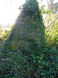
[[Image:CloughagaddyStone.jpg|200px|thumb|right|Photograph of the "stone of the thief"]] | [[Image:CloughagaddyStone.jpg|200px|thumb|right|Photograph of the "stone of the thief"]] | ||
At one time this was a well-known landmark in the angle between the [[Cloghagaddy]] road and the [[Golan]] Road. | At one time this was a well-known landmark in the angle between the [[Cloghagaddy]] road and the [[Golan]] Road. However, about 40 years ago, both roads were raised to make the junction safer with the result that the site of the stone is sunk below road level. | ||
This photograph was taken recently from the field for it is completely covered with ivy viewed when from the road. Here is the opinion of the surveyor for the Ordinance Survey 1835 in his record for Galloon parish. | This photograph was taken recently from the field for it is completely covered with ivy viewed when from the road. Here is the opinion of the surveyor for the Ordinance Survey 1835 in his record for Galloon parish. | ||
{{quotation|''“PAGAN ANTIQUITIES”<br>There are numerous small raths or forts all through the parish, but there is nothing remarkable in any of them. There is in Cloughagaddy townland very near to the parish boundary and a few chains north of the old road from Newtownbutler to Aghadrumsee, a large stone which gives the name to the townland called Cloghagaddy or “the thief’s stone”. The story is that a man of the name of Mulligan went to steal sheep on the mountain. He put one on his back with a foreleg on each side of his own neck, and tied the legs together, then, leaning against the stone to rest himself, the sheep plunged, got on the other side and so choked him.''|Ordinance Survey 1835}} | {{quotation|''“PAGAN ANTIQUITIES”<br>There are numerous small raths or forts all through the parish, but there is nothing remarkable in any of them. There is in Cloughagaddy townland very near to the parish boundary and a few chains north of the old road from Newtownbutler to Aghadrumsee, a large stone which gives the name to the townland called Cloghagaddy or “the thief’s stone”. The story is that a man of the name of Mulligan went to steal sheep on the mountain. He put one on his back with a foreleg on each side of his own neck, and tied the legs together, then, leaning against the stone to rest himself, the sheep plunged, got on the other side and so choked him.''|Ordinance Survey 1835}} | ||
Revision as of 10:30, 11 June 2011
<slippymap h=300 w=450 z=17 lat=54.2187279 lon=-7.3408780/>

At one time this was a well-known landmark in the angle between the Cloghagaddy road and the Golan Road. However, about 40 years ago, both roads were raised to make the junction safer with the result that the site of the stone is sunk below road level.
This photograph was taken recently from the field for it is completely covered with ivy viewed when from the road. Here is the opinion of the surveyor for the Ordinance Survey 1835 in his record for Galloon parish.
“PAGAN ANTIQUITIES”
There are numerous small raths or forts all through the parish, but there is nothing remarkable in any of them. There is in Cloughagaddy townland very near to the parish boundary and a few chains north of the old road from Newtownbutler to Aghadrumsee, a large stone which gives the name to the townland called Cloghagaddy or “the thief’s stone”. The story is that a man of the name of Mulligan went to steal sheep on the mountain. He put one on his back with a foreleg on each side of his own neck, and tied the legs together, then, leaning against the stone to rest himself, the sheep plunged, got on the other side and so choked him.– Ordinance Survey 1835